lol does "traffic" even exist in the shire?
However, Capsis insisted there were major environmental problems that should be discussed.
''Yes, there are problems - there's flood issues for a start,'' he told The Sun-Herald.
''The risk of a flood at Shark Park isn't some kind of big secret - it flooded a few years ago.
''It is one of a few issues that need to be seriously looked at.
''It's a flood plain and these areas flood. It happened [at Toyota Stadium] a few years ago and all I can say is people have a short memory.
''These so-called one in a hundred year floods seem to be happening a lot more regularly.''
http://www.smh.com.au/rugby-league/...ficially-a-club-in-crisis-20110219-1b07i.html
However in 2006 this;
Council approached the State Government, seeking approval for a Local Environmental Plan to allow for development on-site, as part of a plan for the clubs long-term future.
This includes a possible conference centre, seniors housing, hotel accommodation, motel and shops on Captain Cook Drive at Woolooware.
These changes, along with Councils Development Control Plan, will ensure any development of the Cronulla-Sutherland Leagues Club is appropriate.
The plan relates to the part of the site where the Leagues Club building and carpark are currently situated. Shark Park will not be affected.
The plan also includes:
the construction of a 40 metre-wide environmental buffer to help protect the Towra Point Aquatic Reserve and Woolooware Bay; and
at least five metres between any development and a public road, property boundary, public open space, environmental buffer or proposed open space.
Member for Miranda, Barry Collier, said the development was designed to generate local jobs, create extra community and recreational opportunities and potentially add important facilities for seniors.
http://www.planning.nsw.gov.au/mediarelplan/fs20060404_332.html
So tell me this;
Has global warming moved at such an alarming rate since 2006 or was Council happy to support a development on a flood plain on the basis that they would only have to watch a bunch of oldies in the aged care facility, float up the bay once in one hundred years?
Hypocritical bunch on nimbys!
Interesting thread, good to read a range of views.
There's been a challenge set about providing proof of flooding for the site, and how the Council views whether the site is flood-prone... this is from the Sutherland Shire Council website (http://www.sutherlandshire.nsw.gov.au/Environment/Waterways/Flooding_in_Sutherland_Shire):
STUDY NAME
Lower Georges River Floodplain Risk Management Study & Plan
DATE
ongoing
RIVERS AND CREEKS IN STUDY
Lower Georges River from confluence with Woronora River downstream to Botany Bay
DOCUMENTS
[none - usually weblinks for other studies]
So, one can assume by "ongoing" that the Council has been or is re-evaluating whether the area including Endeavour Field and surrounds is flood prone?
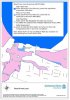
But, digging a little bit deeper into the Council site, via the "Shire Maps" link in the first paragraph, you can pull up the Council Flood Prone Land map.... If this works, I have attached the pic for the area around Endeavour Field to this post - there are clearly "areas of potential flood prone land" (pink) and "areas below the flood planning level" (blue) on that site.
It shows clear flood zone issues with the blue area (which I remember in years gone by as a field/parking lot?), and more worryingly the pink area over Solander Filed (if that's part of the proposed development). That's as good as it gets that there's proof it is considered a flood worry, and no wonder the development plans are not sailing through approvals smoothly...
It looked like the Medium Blue to my eyes - still deemed to be a flood prone area (for those posters earlier on this page demanding some sort of proof). But yes, not one envisioned to have major problems with evacuation needs.If you look closely, the BLUE you refer to is in fact the lighter blue and hence not considered needing a flood management plan. The white is not at risk and the pink ( I believe to be outside the building area) is considered to be in need of a flood risk management plan.
Hardly damaging material in my opinion and nothing unusual for any bay side development.
Just saw a great sign "sick of sitting in traffic? Theres much more to come... Stopthesharksdevelopment.com" just at that round about down from cronulla station near tompkin oval. I actually laughed, did a u turn and tried to take a pic. Too hard to do while driving though
Just saw a great sign "sick of sitting in traffic? Theres much more to come... Stopthesharksdevelopment.com" just at that round about down from cronulla station near tompkin oval. I actually laughed, did a u turn and tried to take a pic. Too hard to do while driving though


As for these pictures on the home page, I actually think they do the developer a favour. They don't look too bad imo.
Legitimate question, but do the current and previous proposals occupy the same site? Are the buildings in the same spots? Are the development footprints similar, and in the same locations? By the sound of the above, the 2006 proposal seems to have been for a significantly smaller development. Can anyone tell more about this?
Also, how do you have 5m "between any development and... (an) open space"? Surely the space goes right up to the building's edge?